
SPECIAL HOLIDAY CASH PRICE DISCOUNT!!!
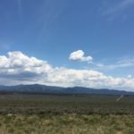
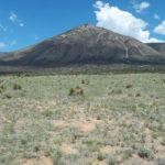
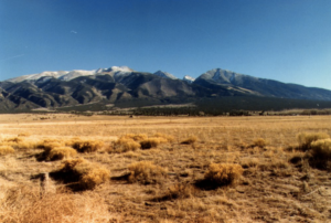
This area is a beautiful place to live and visit. With so many natural wonders, outdoor trails, and wildlife people will continue to be drawn to the San Luis Valley!!
NO SELLER FINANCING AVAILABLE ON THIS ONE**
NE Corner: 37.010457, -105.645977
NW Corner: 37.010337, -105.650397
SW Corner: 37.008572, -105.650365
SE Corner: 37.008615, -105.645923
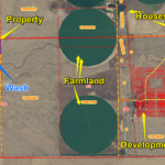
Link To Property Map
History of Mesita
http://www.slvufo.com/mesita.html
About Costilla County and the San Luis Valley
The San Luis Valley
The San Luis Valley, North America’s largest alpine valley, sits at the south-central border of Colorado and New Mexico, beginning just above of Taos, NM and extending north to Poncha Pass, near Villa Grove, CO. Highways 160 (east-west) and 285 (north-south) are the region’s primary transportation veins.
Zapata is located at the eastern edge of the valley, at the junction of Highway 150 and Lane 6 North — about 15 miles east of the town of Mosca and five miles south of Great Sand Dunes National Park and Preserve.
The San Luis Valley sits at about 7,500 feet above sea level, in a semi-arid region ringed on all sides by mountains. The climate is dry and temperate for three seasons, with sunny, warm, pleasant summers and cool, breezy springs and falls. Winters can be harsh, with daytime temperatures averaging in the 20s and often dipping well below zero at night. Snowfall is common from October through April and accumulates in the foothills and mountains (including Zapata), usually melting off quickly in the lower elevations.
Great Sand Dunes National Park and Preserve
Just north of Zapata is one of North America’s largest dune fields, and one of the most biologically diverse park in the United States. Miles of drifting, changing, ethereal dunes stretch out in every direction, and soar as high as 700 feet above visitors. In the lush landscape surrounding the dunes, mule deer, elk, black bears, mountain lions, coyotes, eagles, hawks and other wildlife share the park with more than 300,000 visitors each year. Many of these animals share a community back yard with Zapata residents.
More information about the park
Surrounding area
Mosca and Hooper
These two small, rural towns on State Highway 17 serve as the gateway to Zapata and the Great Sand Dunes for travelers coming from points north. Mosca is home to the Colorado Gator Park (you read that right!) and the Mosca Pit Stop, a convenience store, gas station and popular, local watering hole. Just north of Mosca near Hooper is the famed UFO Watchtower, a collection of other-worldly memoribilia and a raised platform for prime outer space viewing. Hooper is also home to the Hooper Pool – a deceptively simple name for a divine, geothermal swimming experience.
Crestone
Called the Hamlet of the San Luis Valley, Crestone is a small but active arts community on the north side of the Great Sand Dunes National Park and Preserve. Holistic living, eco-building, solar power and other modern, back-to-the-land values are popular here, as is a connected community devoted to artisan culture.
Blanca, Fort Garland and San Luis
This trio of small towns on the southeastern edge of the San Luis Valley have a rich Hispanic history visible in their architecture and community events. Blanca’s two small grocers are a popular place for Zapata residents to stop for the basics, and the community center along US Route 160 between Blanca and Fort Garland offers residents an array of fitness and educational opportunities at low cost.
San Luis, just a few miles from the New Mexico border, is seeing a resurgence in its arts and cultural community. Between these three towns there’s no shortage of hometown-style diners – both Mexican and American – to choose from.
Alamosa and Monte Vista
The business and cultural center of the San Luis Valley, Alamosa is home to just under 10,000 people, dozens of dining options, several hotels, retail stores, grocery stores, parks, galleries, the fabled Rio Grande and its namesake, the Rio Grande Scenic Railroad.
Despite being just half that size, Alamosa’s sister city, Monte Vista, is also bustling, with a charming, active downtown, a rural livestock events center and a wildlife refuge that’s home to some 25,000 migrating Sandhill Cranes each spring and fall.
Other unique facts and fables about the area
The San Luis Valley covers an area of about 8,000 miles, about the size of the state of Connecticut, but its total population is less than 50,000.
The valley’s economic engines are tourism and agriculture. Potatoes and barley are the main crop.
There are more than 500 known artists living in the San Luis Valley today.
Native American legend holds that the San Luis Valley is the site of “Sipapu,” or place of emergence. They believe their ancestors gathered to this special place to be led underground and await the cleansing of the earth and the coming of the new world. It’s believed that the exact spot of Sipapu is near the San Luis Lakes, not far from Zapata.
Eighty acres of fields outside Mosca are now home to the largest solar installation of its kind in North America.
The San Luis Valley enjoys more than 300 days of sunshine each year.
Links to more information
San Luis Valley Info: SLV Dweller
Alamosa Info: Alamosa Convention and Visitor’s Bureau
SLV News Wiki Valley Courier
The San Luis Valley on Wikipedia
Tax Collector Office: http://www.colorado.gov/cs/Satellite/CNTY-Costilla/CBON/1251595035177
Property Appraiser Office: http://www.colorado.gov/cs/Satellite/CNTY-Costilla/CBON/1251594973867
Land Use:
Very few restrictions. To reside on the property for more than 14 days per year, you must install a legally permitted septic system. While building your dwelling, you may get a permit to stay on the land for 90 days. You may continue to extend this permit for up to 18 months. Mobile homes are allowed, but must be less than 25 years old.
For more details regarding land use, permitting, etc. go to: https://www.colorado.gov/pacific/costillacounty/planning-zoning
General Area Info about Utilities and Services
Electricity: (San Luis Valley Rural Electric: Troy 719-852-6654, tgolden@slvrec.com. Xcel Energy xcelenergy.com. The Rural Electric Association has power throughout the valley, providing power to outlying areas. Property owners may obtain their extensions depending upon their location. It may be desirable and cost effective to install a privately owned generator or solar/generator power supply. Some recent owners installed Photovoltaic Panels and residential windmills. Propane gas service is available through several companies located in nearby towns.
Water: Individual wells for household purposes may be drilled on most parcels. Many choose to have tanks delivered. Permits and requirements should be confirmed by the Colorado Division of Water Resources office, 719-589-6683.
Sewer: Septic tank and leach field systems are required. Permits and requirements should be confirmed by the Costilla County Land Use Office, 719-672-9109. *You must adhere to county health and safety code if you intend to live on the property.
Telephone: Cellular phone service is available and phone lines vary in distance from the home sites, according to your location.
Farming is the lifeblood of the San Luis Valley economy.
With a short growing season the main crops are potatoes, barley, and alfalfa. Smaller areas of lettuce, carrots, canola, and mushrooms are also grown.
There are also many ranches raising beef cattle and sheep.
Most of the crop land is irrigated with large center pivot irrigation systems which draw water from the deep underground aquifers.
The soil on the valley floor varies from sandy to rocky as you move from east to west.
On the western side of the San Luis Valley you may notice large piles of rocks in the corners of fields.
This is called potato rock as it is removed from the soil to make farming easier.
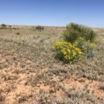
Any land that is not farmed or grazed is covered in “chico” which is low brush such as rabbitbrush or greasewood.
Future
It is unclear what the future may bring.
The San Luis Valley has been experiencing droughts for the past several years. With low snowpack in the mountains there is less water for the farmer’s crops.
Water is the life of farming and without water this area could not exist.
It is uncertain what the future will bring in regards to water, farming, and the people that call the Valley home.
Whatever does happen, this area is a beautiful place to live and visit. With so many natural wonders, outdoor trails, and wildlife people will continue to be drawn to the San Luis Valley!!
*Note: as of the posting of this add 10/8/16, we do not yet have actual property photos. These are nearby and indicative of the area.